Turkiye Volcanoes
-
Tenduruk Dagi
-
Nemrut Dagi
-
Nemrut Dagi
-
Ararat
-
Kula
-
Ararat
-
Nemrut Dagi
-
Tenduruk Dagi
-
Erciyes Volcanic Complex
-

Ararat
-

Ararat
-
Hasandag-Keciboyduran Volcanic Complex
-
Ararat
-
Tenduruk Dagi
-
Ararat
-
Ararat
Turkiye has 7 Holocene volcanoes. Note that as a scientific organization we provide these listings for informational purposes only, with no international legal or policy implications. Volcanoes will be included on this list if they are within the boundaries of a country, on a shared boundary or area, in a remote territory, or within a maritime Exclusive Economic Zone. Bolded volcanoes have erupted within the past 20 years. Suggestions and data updates are always welcome ().
| Volcano Name | Location | Last Eruption | Primary Volcano Type |
|---|---|---|---|
| Ararat | Eastern Turkiye | 1840 CE | Stratovolcano |
| Erciyes Volcanic Complex | Central Turkiye | 6880 BCE | Stratovolcano |
| Hasandag-Keciboyduran Volcanic Complex | Central Turkiye | Unknown - Evidence Credible | Stratovolcano |
| Karaca Dag | Eastern Turkiye | Unknown - Evidence Credible | Shield |
| Kula | Western Turkiye | Unknown - Evidence Credible | Volcanic field |
| Nemrut Dagi | Eastern Turkiye | 1650 CE | Stratovolcano |
| Tenduruk Dagi | Eastern Turkiye | 1855 CE | Shield |
Chronological listing of known Holocene eruptions (confirmed or uncertain) from volcanoes in Turkiye. Bolded eruptions indicate continuing activity.
| Volcano Name | Start Date | Stop Date | Certainty | VEI | Evidence |
|---|---|---|---|---|---|
| Tenduruk Dagi | 1855 | Unknown | Confirmed | Observations: Reported | |
| Ararat | 1840 Jul 2 | Unknown | Confirmed | 3 | Observations: Reported |
| Ararat | [1783] | [Unknown] | Uncertain | ||
| Nemrut Dagi | [1692 Apr 13] | [Unknown] | Uncertain | ||
| Nemrut Dagi | 1650 Oct 27 | Unknown | Confirmed | Observations: Reported | |
| Nemrut Dagi | 1597 (in or before) | Unknown | Confirmed | Observations: Reported | |
| Ararat | [1450] | [Unknown] | Uncertain | ||
| Nemrut Dagi | 1441 | Unknown | Confirmed | Observations: Reported | |
| Nemrut Dagi | 1402 (?) | Unknown | Confirmed | Sidereal: Varve Count | |
| Nemrut Dagi | 1111 | Unknown | Confirmed | Observations: Reported | |
| Erciyes Volcanic Complex | [0253 (in or before)] | [Unknown] | Uncertain | ||
| Nemrut Dagi | 0531 BCE (?) | Unknown | Confirmed | Sidereal: Varve Count | |
| Ararat | 0550 BCE | Unknown | Confirmed | Correlation: Anthropology | |
| Tenduruk Dagi | 0550 BCE (?) | Unknown | Confirmed | Isotopic: 14C (uncalibrated) | |
| Nemrut Dagi | 0657 BCE ± 25 years | Unknown | Confirmed | Sidereal: Varve Count | |
| Nemrut Dagi | 0787 BCE ± 25 years | Unknown | Confirmed | Sidereal: Varve Count | |
| Nemrut Dagi | 1396 BCE (?) | Unknown | Confirmed | Sidereal: Varve Count | |
| Nemrut Dagi | 1662 BCE (?) | Unknown | Confirmed | Sidereal: Varve Count | |
| Nevsehir-Acigol Volcanic Complex | [2080 BCE ± 200 years] | [Unknown] | Uncertain | ||
| Nevsehir-Acigol Volcanic Complex | [2370 BCE ± 200 years] | [Unknown] | Uncertain | ||
| Ararat | 2450 BCE ± 50 years | Unknown | Confirmed | Correlation: Anthropology | |
| Nevsehir-Acigol Volcanic Complex | [3500 BCE (?)] | [Unknown] | Uncertain | ||
| Nemrut Dagi | 4055 BCE ± 50 years | Unknown | Confirmed | Sidereal: Varve Count | |
| Nemrut Dagi | 4321 BCE (?) | Unknown | Confirmed | Sidereal: Varve Count | |
| Nemrut Dagi | 4615 BCE (?) | Unknown | Confirmed | Sidereal: Varve Count | |
| Nemrut Dagi | 4849 BCE (?) | Unknown | Confirmed | Sidereal: Varve Count | |
| Nemrut Dagi | 4938 BCE ± 75 years | Unknown | Confirmed | Sidereal: Varve Count | |
| Nemrut Dagi | 5085 BCE (?) | Unknown | Confirmed | Sidereal: Varve Count | |
| Nemrut Dagi | 5152 BCE (?) | Unknown | Confirmed | Sidereal: Varve Count | |
| Nemrut Dagi | 5242 BCE ± 75 years | Unknown | Confirmed | Sidereal: Varve Count | |
| Nemrut Dagi | 5320 BCE (?) | Unknown | Confirmed | Sidereal: Varve Count | |
| Nemrut Dagi | 5745 BCE (?) | Unknown | Confirmed | Sidereal: Varve Count | |
| Nemrut Dagi | 6213 BCE (?) | Unknown | Confirmed | Sidereal: Varve Count | |
| Nevsehir-Acigol Volcanic Complex | [6230 BCE (?)] | [Unknown] | Uncertain | ||
| Nemrut Dagi | 6471 BCE (?) | Unknown | Confirmed | Sidereal: Varve Count | |
| Hasandag-Keciboyduran Volcanic Complex | [6750 BCE ± 50 years] | [Unknown] | Uncertain | ||
| Erciyes Volcanic Complex | 6880 BCE ± 40 years | Unknown | Confirmed | Isotopic: 14C (calibrated) | |
| Nemrut Dagi | 7087 BCE (?) | Unknown | Confirmed | Sidereal: Varve Count | |
| Hasandag-Keciboyduran Volcanic Complex | [7550 BCE ± 50 years] | [Unknown] | Uncertain | ||
| Nemrut Dagi | 7579 BCE (?) | Unknown | Confirmed | Sidereal: Varve Count | |
| Nemrut Dagi | 7769 BCE (?) | Unknown | Confirmed | Sidereal: Varve Count | |
| Nevsehir-Acigol Volcanic Complex | [7810 BCE (?)] | [Unknown] | Uncertain | ||
| Suphan Dagi | [8050 BCE (?)] | [Unknown] | Uncertain | ||
| Nemrut Dagi | 9950 BCE ± 150 years | Unknown | Confirmed | Sidereal: Varve Count |
Turkiye has 12 Pleistocene volcanoes. Note that as a scientific organization we provide these listings for informational purposes only, with no international legal or policy implications. Volcanoes will be included on this list if they are within the boundaries of a country, on a shared boundary or area, in a remote territory, or within a maritime Exclusive Economic Zone. Suggestions and data updates are always welcome ().
| Volcano Name | Location | Primary Volcano Type |
|---|---|---|
| Arpacay | Eastern Turkiye | Volcanic field |
| Ceyhan-Osmaniye | Turkey | Volcanic field |
| Derinkuyu Volcanic Complex | Central Turkiye | Lava dome |
| Egrikuyu Monogenetic Field | Central Turkiye | Volcanic field |
| Etrusk | Eastern Turkiye | Stratovolcano |
| Girekol | Eastern Turkiye | Shield |
| Golcuk | Southwestern Turkiye | Caldera |
| Karapinar Monogenetic Field | Central Turkiye | Volcanic field |
| Karasu Rift | Turkey | Volcanic field |
| Kisir Dagi | Eastern Turkiye | Unknown |
| Nevsehir-Acigol Volcanic Complex | Central Turkiye | Complex |
| Suphan Dagi | Eastern Turkiye | Stratovolcano |
There are 21 photos available for volcanoes in Turkiye.
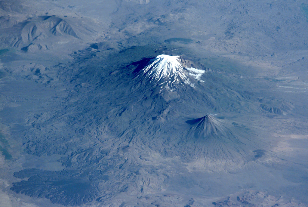
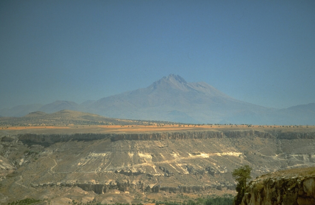
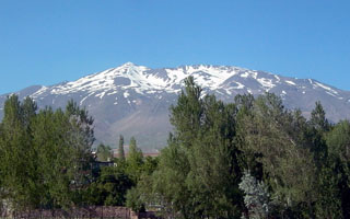
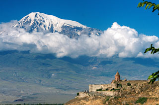 Snow-capped Mount Ararat is seen from the Khor Virap monastery in Armenia, NE of the volcano. Ararat, also known as Agri Dagi, is Turkey's highest and easternmost volcano, lying near the border with Armenia. Ararat appears to have been active during the 3rd millennium BCE; pyroclastic flow deposits overlie early Bronze Age artifacts and human remains.
 Photo by Andrew Behesnilian (Wikimedia Commons).
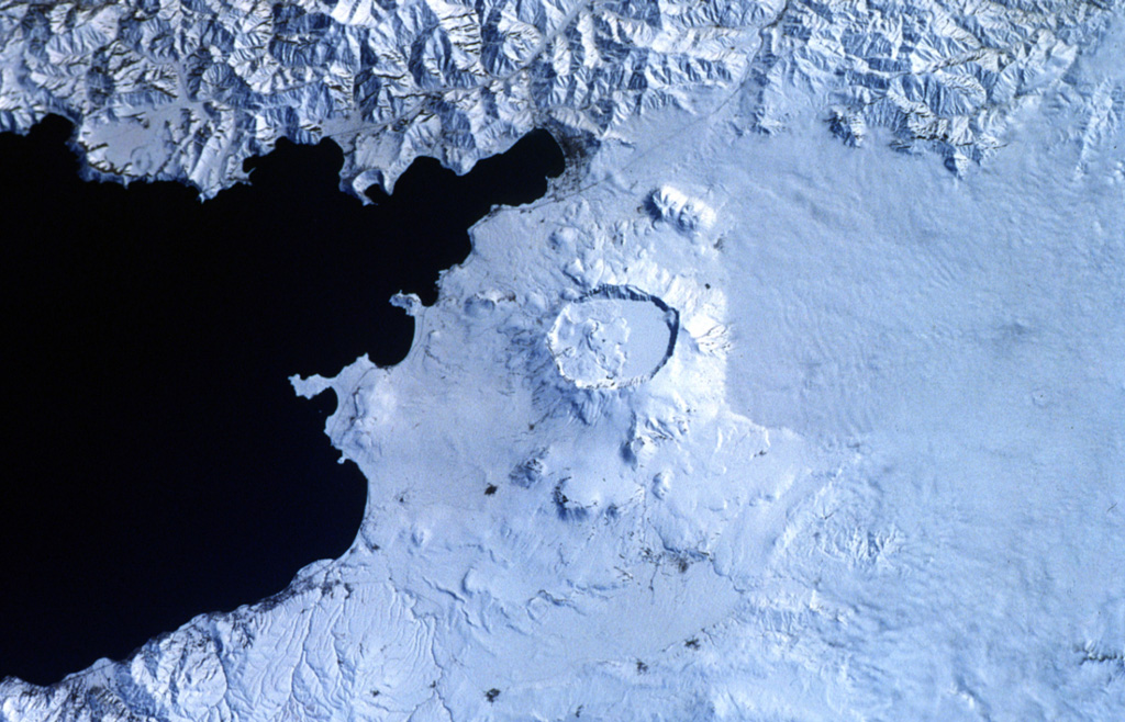
 Snow-capped Süphan Dagi lies immediately north of Lake Van. A large lava dome was constructed over the central vent, and the flanks of the volcano contain numerous lava domes and cones that erupted along radial and circumferential fissures.
Photo by Murat Erdogan, 2005 (http://en.wikipedia.org/wiki/Image:Suphan_Dagi.jpg).
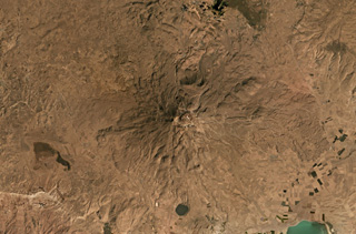
 The Göllü Dag volcanic complex in Turkey is shown in this August 2019 Planet Labs satellite image monthly mosaic (N is at the top; this image is approximately 35 km across). The 10-12-km-wide complex formed through the coalescence of at least ten rhyolite domes, with scoria cones, lavas, ignimbrites, and over 25 vents surrounding them. The Aci Gölü maar contains the lake to the upper left, with several scoria cones nearby. The domes are in a rough southeast trend from this maar and have erosion gullies on their flanks.
Satellite image courtesy of Planet Labs Inc., 2020 (https://www.planet.com/).
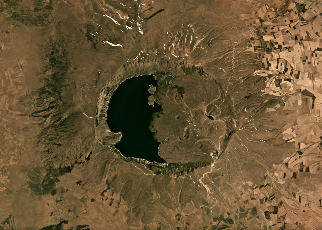
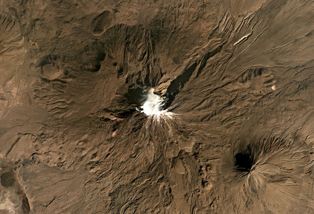
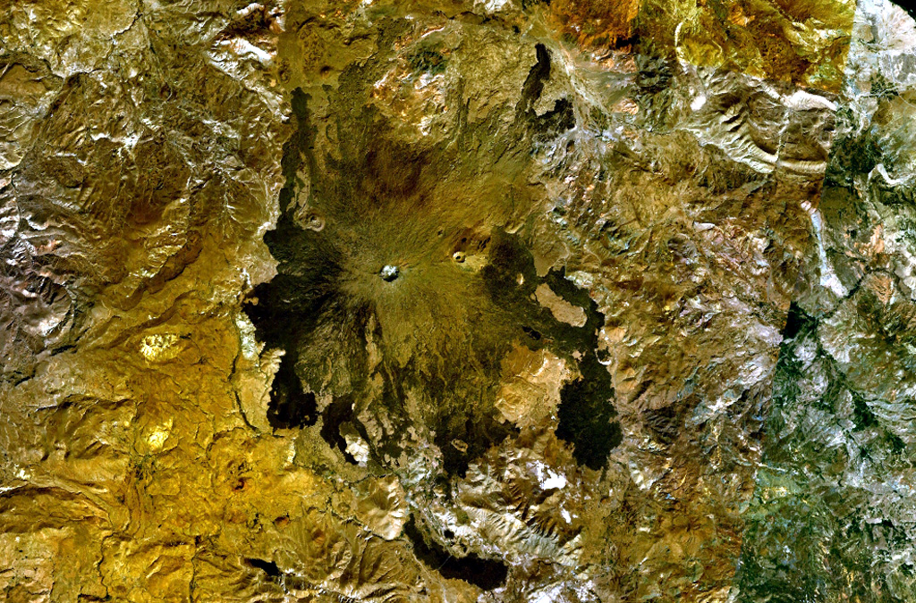
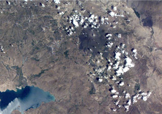
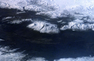
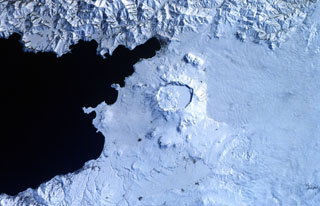 The prominent caldera in the center of the photo is Nemrut Dagi, the westernmost of a group of volcanoes near Lake Van. Nemrut Dagi lies north of the western part of Lake Van and is the only one of the group that has erupted in historical time. The 5 x 9 km caldera is partially filled by a lake, which appears as the smooth snow-covered right side of the caldera floor in this Space Shuttle photo with north to the bottom. Ash layers in Lake Van document numerous Holocene eruptions, the last of which took place in 1441 CE.
NASA Space Shuttle image STS45-80-08, 1992 (http://eol.jsc.nasa.gov/).
 Glacier-clad Mount Ararat, seen in this NASA International Space Station image, is Turkey's highest, largest volume, and easternmost volcano. Kucuk Ararat (or Lesser Ararat) lies across a saddle to the SE (right-center). Prominent lava flows with flow levees were erupted from flank vents between Greater and Lesser Ararat; one of these terminates in a fan-shaped lobe at the lower left. Pyroclastic-flow deposits from Ararat overlie early Bronze Age artifacts.
NASA International Space Station image ISS002-E-10032, 2001 (http://eol.jsc.nasa.gov/).
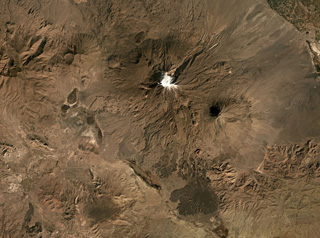
 The double-peaked Hasan Dagi volcano in central Turkey has a complex history that includes three episodes of caldera collapse. Numerous cones, maars, and lava flows dot the flanks of the volcano. The hilly terrain in the foreground is a debris avalanche deposit produced by collapse of the volcano.
Photo by Richard Waitt, 1994 (U.S. Geological Survey).
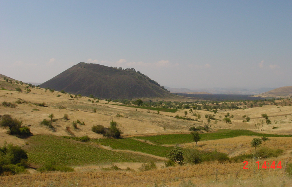
 The Kara Divlit Tepe ("Black Ink Cone") scoria cone is part of the Kula volcanic field, the westernmost area of young volcanism in Turkey. It is the youngest of the broad Quaternary volcanic field, which is mostly Pleistocene in age. The 300-m-high cone produced a voluminous lava flow (visible to the N, right of the cone) that traveled 22 km NW and is one of the two youngest flows at Kula. The Kula volcanic field contains a group of cones and maars erupted along a roughly E-W-trending line.
Photo by Samuele Agostini, 2000 (CNR, Pisa, Italy).
 Süphan Dagi in Turkey is in the center of this September 2019 Planet Labs satellite image monthly mosaic (N is at the top; this image is approximately 40 km across). To the south is Aygirgölü maar which is just under 2 km in diameter. Lava flows are visible across the eroded flanks.
Satellite image courtesy of Planet Labs Inc., 2019 (https://www.planet.com/).
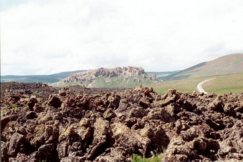
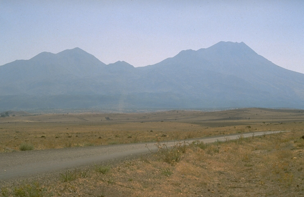
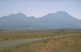
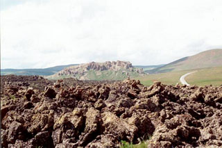 Rough `a`a lava flows in the foreground occupy the slopes of Tendürek Dagi volcano. This volcano rises 1,800 m above the plain of Dogubayazit, near the Iranian border, S of Mount Ararat. The latest activity formed two major basaltic lava flows from large cones on the NE and SE flanks. An eruption took place from a vent on the SE flank about 2,500 years ago, and an eruption took place in 1855.
Photo by Joël Boyer, 1993 (L.A.V.E.)
 The dark-colored circular area above and to the right of the center of this NASA International Space Station image (with north to the top) is Tendürek Dagi. This shield volcano rises 1,800 m above the plain of Dogubayazit, near the Iranian border, NE of Lake Van (whose NE tip is at the lower left) and S of Mount Ararat (out of view to the upper right). An eruption took place from a vent on the SE flank of Tendürek Dagi about 2,500 years ago, and another eruption occurred in 1855.
NASA International Space Station image ISS002-E-7778, 2001 (http://eol.jsc.nasa.gov/).
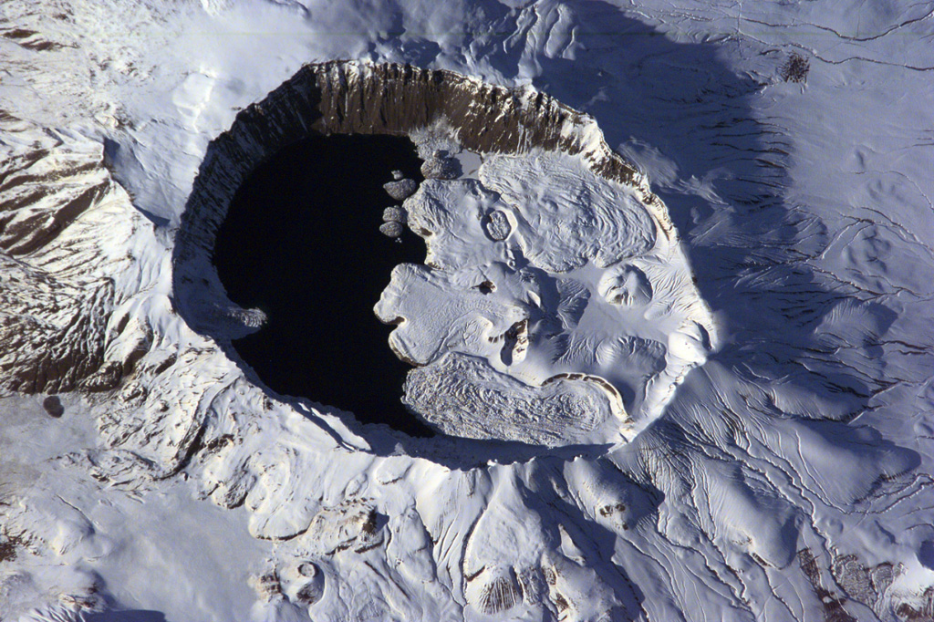
 The summit of Nemrut Dagi is truncated by a 5 x 9 km caldera near Lake Van in eastern Turkey. A lake that partially fills the western side of the caldera is constrained by post-caldera eruptions that produced glassy obsidian lava flows from domes on the eastern caldera floor. A series of scoria cones and lava domes were erupted along N-S-trending fissures on the northern flank. Ash layers in Lake Van document numerous Holocene eruptions from Nemrut Dagi.
NASA International Space Station image ISS001-E-6354, 2001 (http://eol.jsc.nasa.gov/).
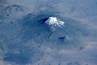
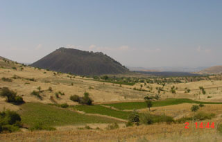
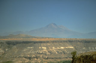 Erciyes Dagi volcano in central Turkey, seen here from the WSW, is an eroded stratovolcano that covers an area of 1,300 km2. Numerous parasitic cones and lava domes are concentrated on its northern flank.
 Photo by Richard Waitt, 1994 (U.S. Geological Survey).
 This Space Shuttle image shows the massive 1,000 km3 snow-capped Ararat massif in March 2001. The N-trending feature descending at the top-center from the summit crater is Ahora Gorge. The conical peak of Kucuk Ararat (Lesser Ararat) is visible at the far right, and craters can be seen on the western flank of the massif at the left.
Image courtesy of Earth Sciences and Image Analysis Laboratory, NASA Johnson Space Center, 2001 (http://eol.jsc.nasa.gov).
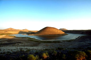 Meke Golu lake surrounds the Meke Dagi scoria cone in the Karapinar volcanic field, which is comprised of cones, lava fields, and maars on the Konya-Eregli plain. The 300-m-high Meke Dagi is one of the largest cinder cones in Central Anatolia. This maar complex evolved from a hyaloclastite tuff ring to a maar to a scoria cone, reflecting varying lake water levels during the eruption.
Copyrighted photo by Marco Fulle, 1999 (Stromboli On-Line, http://stromboli.net).
 Mount Ararat has two main edifices, the glaciated Buyuk Ağrı in the center and the smaller Kucuk Ağri to the SE of this October 2019 Planet Labs satellite image monthly mosaic (N is at the top; this image is approximately 33 km across). The flanks are lava flows, lava domes, craters, and explosive deposits.
Satellite image courtesy of Planet Labs Inc., 2019 (https://www.planet.com/).
 Mount Ararat, or the Ağri Daği volcanic complex, in Turkey has two main edifices, Buyuk Ağrı near the center of this image and the smaller Kucuk Ağri to the SE, both seen in this October 2019 Planet Labs satellite image monthly mosaic (N is at the top; this image is approximately 40 km across). Large recent lava flows form the darker areas to the S of the main glaciated cone.
Satellite image courtesy of Planet Labs Inc., 2019 (https://www.planet.com/).
 Two circular craters lie along an E-W trend on the summit ridge of Tendürek Dagi shield volcano in this NASA Landsat composite image (with north to the top). The higher western cone is capped by a steep-walled crater, and the flatter eastern crater contains a lake. Late-stage activity formed trachytic lava domes and flows as well as basaltic pahoehoe flows that extend 10-20 km N and S.
NASA Landsat 7 image (worldwind.arc.nasa.gov)
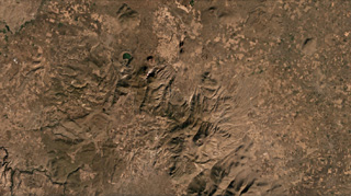
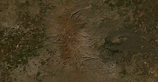 The Karaca Dag/ Karacadağ shield volcano covers around 10,000 km2 in Turkey, with the more recent N-S plateau of scoria cones and lava flows down the center of this January 2020 Planet Labs satellite image monthly mosaic (N is at the top; this image is approximately 63 km across). A younger group of lava flows erupted from vents on the eastern flank, appearing darker with the vents visible.
Satellite image courtesy of Planet Labs Inc., 2021 (https://www.planet.com/).
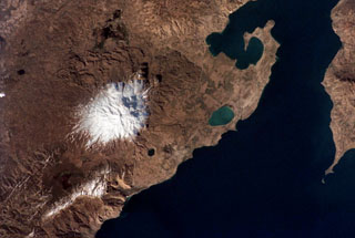 Snow-capped Süphan Dagi volcano seen from the International Space Station, with north to the upper left. The flanks of the volcano contain numerous lava domes and cones that erupted along radial and circumferential fissures. The small black lake halfway between the snow line and Lake Van is the 1.5-km-wide Aygirgölü maar; the larger greenish Lake Arin is visible to the east.
NASA International Space Station image ISS002-313-9, 2001 (http://eol.jsc.nasa.gov/).
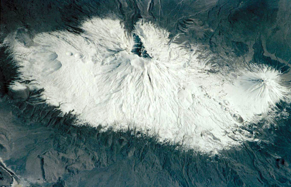
 The snow-covered Mount Ararat massif is seen in the center of this 1992 Space Shuttle photo from the NE. The double-peaked stratovolcano is Turkey's highest, largest volume, and eastern-most volcano, near the borders with Armenia and Iran. Postglacial lava flows were erupted from flank fissures, and well-preserved craters are located on the flanks.
NASA Space Shuttle image, 1992 (http://eol.jsc.nasa.gov/).
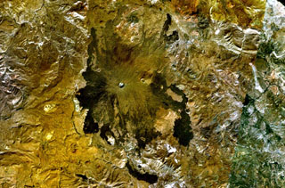
 The eastern half of the 8.5 × 7 km Nemrut Dagi summit caldera is partially filled with lava flows, phreatomagmatic eruption deposits, and lava domes, and the western half is filled with a lake that is seen in this June 2019 Planet Labs satellite image monthly mosaic (N is at the top). The surrounding area contains ignimbrite deposits, tephra, lava domes, and lava flows.
Satellite image courtesy of Planet Labs Inc., 2019 (https://www.planet.com/).
This is a compilation of Turkiye volcano information sources, such as official monitoring or other government agencies.
| Volcanic Ash Advisory Center | |
|---|---|
| Toulouse Volcanic Ash Advisory Center (VAAC) Notices and Archive | |